Millennium Project
-
by Rob Forsyth and Jon Malings
Background to the 1808 Enclosure award can be found in our article about the Deddington open fields and Enclosure. Further information can also be found in our pages about the Deddington Quality Book of 1807, a notebook listing all the pieces of land in the Deddington open fields just prior to enclosure.
The Deddington Award
Enclosure was intended to provide an economic benefit by to farmers, particularly the larger ones. This was achieved by amalgamating the small, scattered strips of land that each person owned in the open fields into larger contigous holdings. A normal byproduct of this major reallocation of land was the production of a map identfying all the new holdings. The notes that follow may assist with interpreting the maps and their keys at the foot of this article.
Notes to the 1808 Award
The 1808 award mapped out the whole of the parish of Deddington. The map showed the position, size and ownership of every property within the three villages of Clifton, Deddington and Hempton together with the land surrounding them. It was not possible for us to record the whole map so only the three villages have been extracted. A single key was contained on the map, it showed:
- The key number of each holding on the map
- The name of the proprietor
- The tenure (freehold, leasehold, etc) and the name of the leaseholder where appropriate
- A brief description
- The plot size in acres/roods/poles, and whether the plot was a new allocation of land or an existing "old inclosure".
In the case of a new allocation the property description sometimes detailed the “swap” arrangements between landholders. For example, key number 109 shows that Samuel Churchill was allocated a holding of around 1¾ acres in exchange for a Close which he gave to William Appletree.
The Key shows that the total land in the parish amounted to 4159 acres, split between 163 proprietors. Most of these were simple householders, but 55 people owned more than 10 acres each. The four largest landowners – Rev. Robert Marriot, William Cartwright, Samuel Churchill and Henry Watkin Dashwood bart., owned more than half of the total land in the parish. As previously mentioned, Robert Marriott, the Impropriate Vicar, owned the income from church tithes so was allocated significant amounts of land as compensation when these were abolished.
For some reason the cartographers used duplicate key numbers for Hempton and Deddington. To distinguish between them the key number was preceded by an asterisk * for holdings in Deddington. Clifton has unique key numbers.
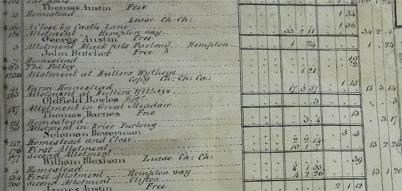
The key is not in strict alphabetic order. The example above reads Butcher, Bowles, Barnes, Bowerman, Bloxham. Also, the proprietors of small properties are placed in separate sections by village.
The key contains four sets of three columns (Acres, Roods and Poles) relating to the size and nature of the holding.
- The first set of three columns is not generally applicable as it relates to Tithes, Glebe, Manerial Rights, Roads and Stonepits
- Set two shows new allotments of land and old inclosures allotted in exchange. The Enclosure award involved significant reallocation of land, the intent being to create viable contigous holdings that could be farmed efficiently compared to the old strip-farmed yardlands.
- Set three identfies old (existing) inclosures. These are typically houses and cottages.
- The final three columns show the total land holding of the individual.
Taking Solomon Bowerman as an example we can see that his first property, key number 142, has an asterisk alongside so it's in Deddington village. It's a Homestead and Close, 3 roods and 5 poles in size, just over ¾ acre. As we might expect, it's in Column 3 - an old inclosure. His second holding, key 176, is a new allotment, as is his third, key 177. Column 4 shows his total holding to be 13 Acres, 2 Roods and 26 Poles.
Some of the holdings (generally outlying fields like Solomon Bowerman's plots 176 and 177) do not appear on any of the 3 village maps.
The full key is available as an EXCEL spreadsheet for those who might want to manipulate the data themselves. Click here
In addition we have provided the following snapshots::
A list of the proprietors
In strict alphabetic order showing the overall size of their their holdings. Click here
By overall size of holding, click here
By Key
By surname
Proprietors in alphabetic order with their individual holdings.
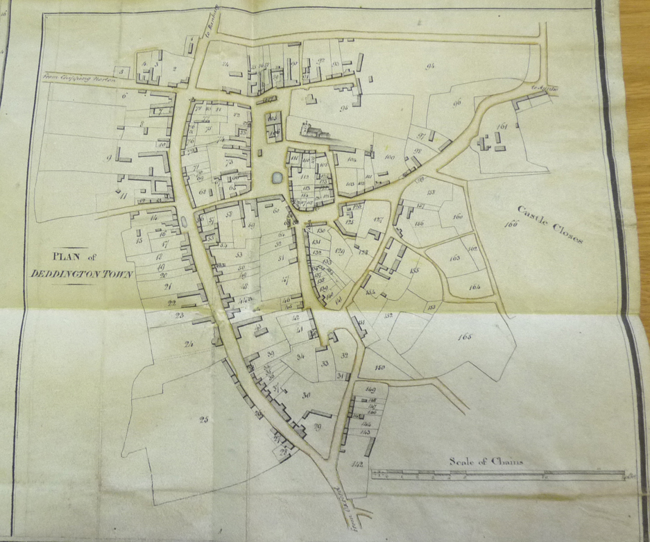
Deddington
The Deddington Village Map (Enclosure Award - courtesy of the Oxford Records Office - see note below)
Relevant keys in numeric order
Relevant keys by Proprietor's surname in alphabetic order
Note: Extracts for Deddington Town, Clifton and Hempton come from the full scale original titled 'Deddington and Barford Award' ORO Reference PAR/86/16/H/1. It is enclosed within the volume containing the original enclosure document and records for the parish. The ORO also hold a second map referenced 'PAR 86/16/M/1 ORIGINAL' which is the map only and on which the key is missing any reference to the extensive property holdings of the Rev Robert Marriot LL.D found in column 3 of the first map. The relevant key numbers are 21,88,80,86,60,99,98,95,166. So whether it was 'the original' or not is uncertain. There are also some very minor differences between the copies in use of spelling and abbreviations which do not affect the sense.
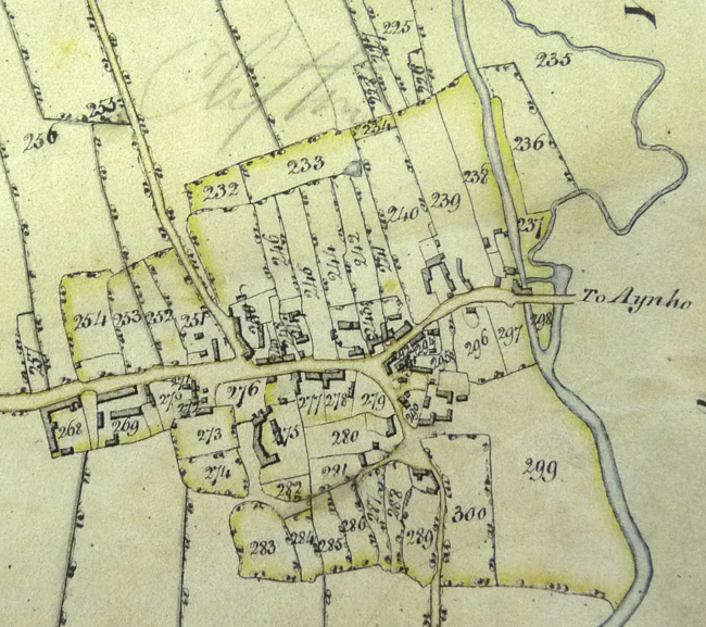
Clifton
The Clifton Village Map (see note above)
Relevant keys in numeric order
Relevant keys by Proprietor's surname in alphabetic order
Hempton
The Hempton Village Map (see note above)
Relevant keys in numeric order
Relevant keys by Proprietor's surname in alphabetic order
Outlying properties and holdings
We were not able to make a clear image of the complete Deddington Parish map because of the nature of the original document. There are, therefore, a number of holdings, mainly outlying fields, which do not appear on any of the three village maps. The principal enclosure allotments map of 1808 is useful in identifying some of these.
Relevant keys in numeric order
Relevant keys by Proprietors surname in alphabetic order