Millennium Project
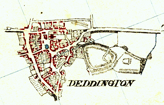
Deddington Street Map
This map is based on the same cartography as used by Peter Terry for the Millennium Maps. It contains just the names of the streets and by-ways in the village. It is not directly printable.
Old maps of the Parish
Over the centuries there have been many maps of the parish and its surrounding area. This section provides links to some of the more notable ones.
A good place to start might be an article in the December 2001 edition of 224*, the magazine of the Deddington & District History Society. This article - called Mapping changing Deddington - takes an overview of the various maps - several of which are linked below - that have covered the history of the parish and discusses some of the inferences that can be drawn from them.
* the title of the D&DHS newsletter is taken from the
sheet number used by the draughtsmen of the Ordnance Survey in the early
years of the 19th century to identify the individual drawings made by
the surveyors for the first edition one inch maps.
1807 The Deddington Quality book was copied by Henry Stilgoe. It was a child's home made exercise book in which he had been told to practice writing his name when he was only 6 or 7 and the words "no gains without pain". and subsequently, in 1807 aged 11 or 12, to copy the Deddington Quality Book containing information that was clearly used in the enclosure process, culminating in the award of 1808. It lists, in detail, nearly 300 subdivisions of land in the Deddington and Barford St. Michael common fields and divides much of the land into differing qualities. The book also lists approximately 100 Deddington homesteads and proprietors.
Quality Books are exceedingly rare items. This one has been in the possession of the Stilgoe family since it was written and we are indebted to the current owner for allowing us to reproduce it on the DOL website. As far as we are aware, this is the only Quality Book to be found online.
The Deddington Enclosure Award of 1808. The Enclosure acts of the 18th and 19th centuries provided comprehensive mapping of many towns and villages. The maps and associated information contained in the 1808 award give a clear picture of the division and ownership of all the property and land in the parish of Deddington.
Jackson's Oxford Journal of 27 August 1808 (Cols 3 & 4) carried a full description of the 'Public and Private Carriage Roads and Highways, Bridleways, and Footways, through and over the Lands and Grounds by the said Act..'
Cartwright Duchy Town plan. This link takes you to an article by Colin Cohen (editor of the History Society's magasine 224) in which he looks at the plan using information from The Cartwright Duchy Manor records.
Principal inclosure allotments. This map comes from Victoria County History in which can also be found the description of farms and inclosures.
Philcote Street and the surrounding area was mainly occupied by agricultural workers and their families. This article looks at it in some detail.
An account of the Land belonging to Henry, Nathaniel and Zachariah Stilgoe. Again, we are indebted to the current owner for allowing us to reproduce this document.
1814 (approx) An early OS survey
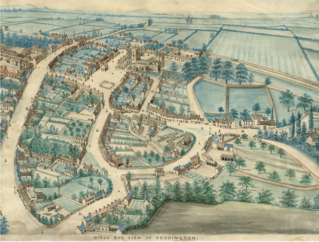
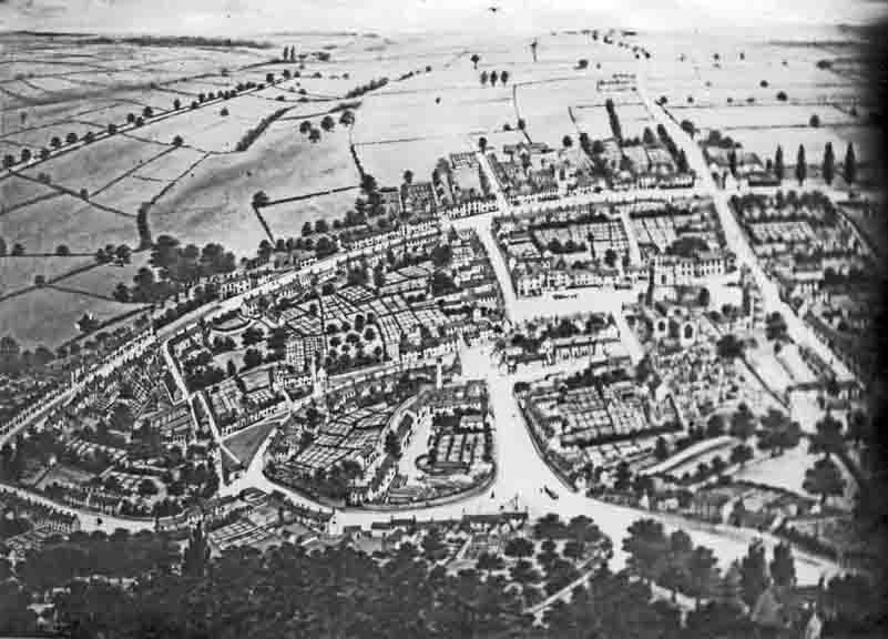
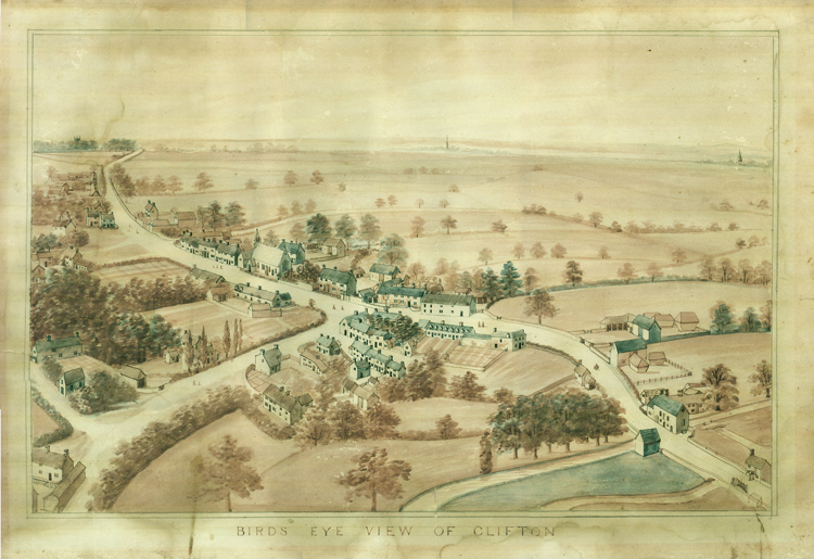
1875 (approx) Joseph Wilkins, a Deddington resident and cartographer, painted imaginary bird's eye views of the village. He lived in Gilkes Style at the south end of New Street - now known as The Stile. A History of Deddington, Oxfordshire by H.M.Colvin, 1963 contains a black and white copy of his view from the south. Colvin dates the drawing at 1875 but close observation shows that the church still has the Georgian porch, which was demolished in 1863. The original colour image of the view from the south - from which Colvin presumably took his copy - is in the archives of the Banbury Museum (accession number OXCMS : ti1446) and is reproduced by courtesy of Oxfordshire County Council Museum Service. A black and white copy of Wilkin's view from the east can be found in Mary Vane Turner's The Story of Deddington. He also painted a view of Clifton (courtesy of a private collection)
1881 North Deddington South Deddington (400Kb pdfs)
Another version of this map can be seen in the 224 article Mapping changing Deddington
1886 & 1889 - maps for these years can be obtained via the website of old-maps.co.uk.
1902 North Deddington South Deddington (400Kb pdfs)
1905 Oxfordshire County History website has a 1905 survey of roads and bridges of the county which can be panned and zoomed to any desired section.
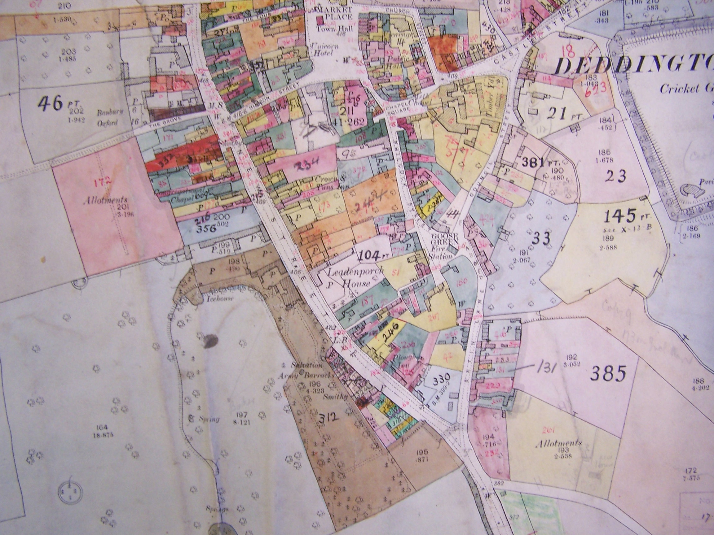
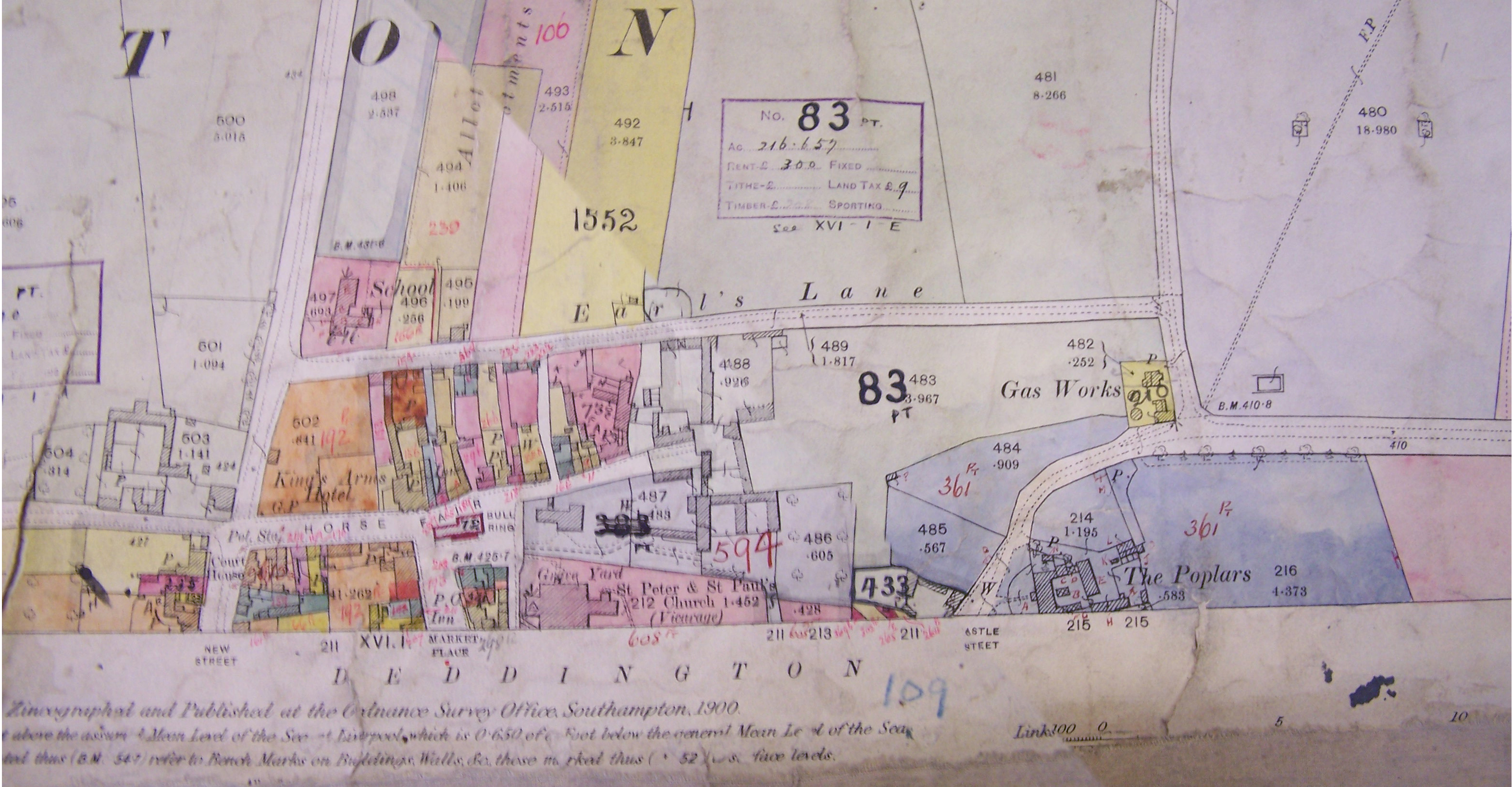
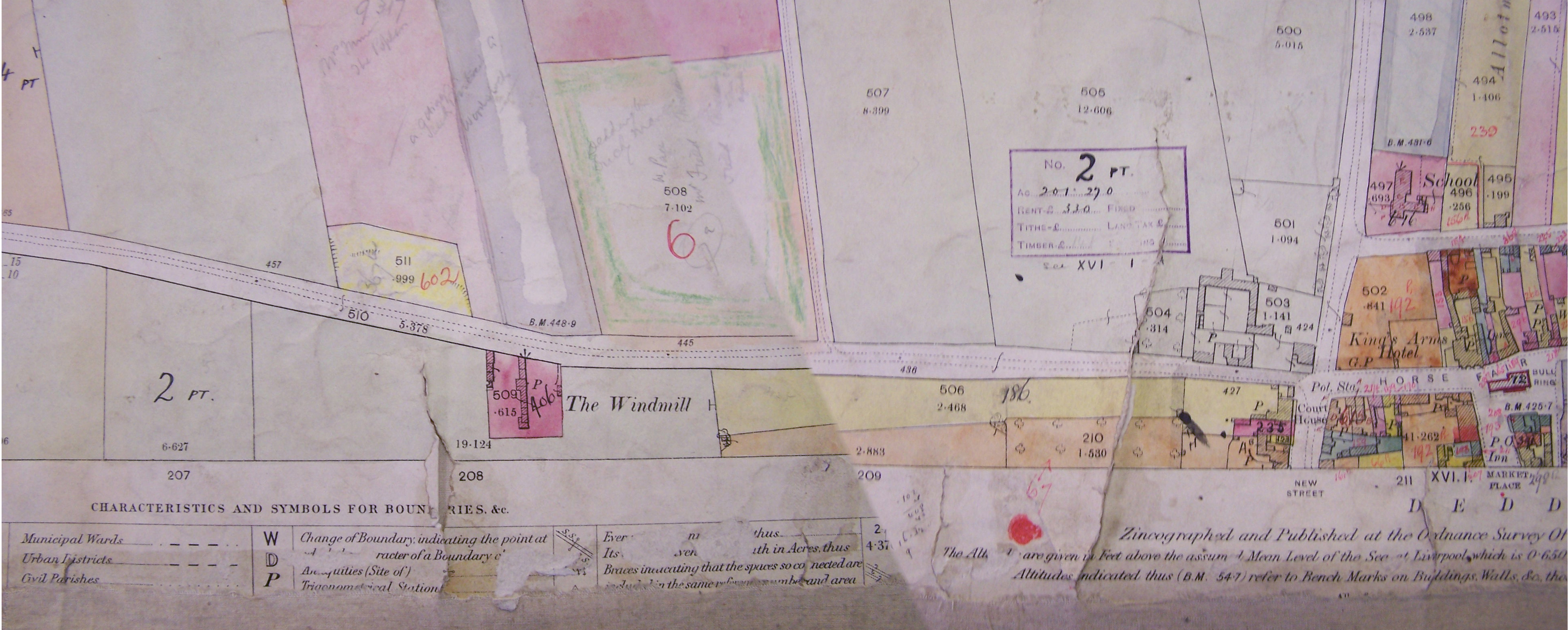
1910 survey for rating valuation purposes This major survey consists of 6 full colour maps based on the OS covering the whole of the parish. They are archived in the Oxford Records Office at St Lukes under the references below. It remains a project to obtain images of all 6 maps and also the associated ledgers, alphabetically keyed to the maps, which contain details of each property. Meanwhile the following ORO references will help anyone wishing to research them.
Deddington: D.V.VIII/86 & D.V.VIII/139
These links show some images of parts of the maps
From the Market Place south to Chapmans Lane
Earls Lane, Horsefair and the Bullring
Hempton: D.V.VIII/79 & D.V.VIII/126
Clifton: D.V.VIII/87 & D.V.VIII/140
Valuation ledgers : D.V.X/45 & D.V.X/46
1923 Two pdfs approx 400Kb each North Deddington South Deddington
1954 Christ Church College sold a large amount of its holdings known as Deddington Estates. The map of their holdings and the accompanying brochure of particulars (4.5Mb pdf) provide a wealth of detail about the parish at that time.
1975 Historic Towns of Oxfordshire (edited by Kirsty Rodwell) recorded the topography of the parish
Deddington in Year 2000 Maps created by the Deddington Map Group to mark the Millenium where you can find a useful street map.
Miscellaneous
A Vision of Britain - Historical Maps is a useful source for old maps
Printed maps of Oxfordshire by John Leighfield with copies of some maps between 1574 & 1833
Copies of annotated maps of Deddington - histiography, archeaology, castle - from Deddington Society archives