Deddington Map Group (DMG)
Published 1998
The following article is based on the original DMG Millenium Project leaflet (pdf) and is published with its kind permission
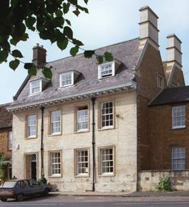
If you stroll, this walk will probably take about an hour. For your convenience, we suggest you print this page and also the associated street map. There is a more detailed street map but which is not printable. Note that the title of each small image below may be clicked on for a larger version.
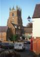

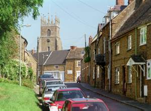
We start our walk at the Town Hall near the centre of the Market Place. As you can see in the street map, the Market Place is roughly rectangular with a neat and tidy green. It wasn't always like this! In 1855 it was described as 'an ugly piece of rocky ground' and it had a highly polluted town pool in the south-east corner. The pool was filled in in 1861.
From the 14th until the 19th century the market was held on Saturdays. By the early 19th century the market had begun to fail and it came to an end in 1830. Various alternatives were tried but a regular market has not been held since 1852. Over time, different annual fairs have been held in the Market Place; the most important was Martinmas (11 November) which, from when it was granted in 1393, lasted for three days. In the early 18th century it was considered a 'great fair' and it continued until the 1930s by which time it had moved to 20 November. It was known as the 'pudding-pie fair', so-called because of the plum-pudding baked in a hard crust of pastry made for the occasion. In the heyday of the fair the centre of the Market Place was reserved for pigs; sheep were sold in the Bull Ring and horses in the Horse Fair - stretching up the road towards Hempton when it was busy.
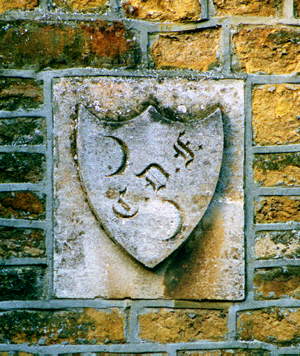
An earlier town hall (probably built on this site in the late 16th century) had an upper room which sat above open arches within which were shops and market stalls; it was used for vestry meetings and as a court house. The hall was rebuilt in 1806 and in 1858 the arches were bricked up to provide a shelter for the parish fire engine where it stayed until the 1930s. On the southern wall is the Coat of Arms which was granted to Deddington on 16 April 1994. Against the north wall is a classic red (type K6) cast iron telephone kiosk; these kiosks were designed in 1935 by Sir Giles Gilbert Scott.


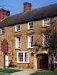
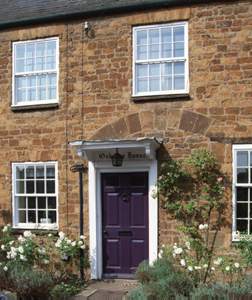
We will come back to the town hall at the end of our walk, but now we go north towards the Deddington Arms - the half-timbered black and white inn (more about this later). On our left just past the Red Lion pub (which was a farmhouse until the mid 19th century) we shortly come to a corner of the Market Place and to an outstanding house called the Hermitage - a name recorded in the 16th century when it was occupied by the town's guild. By the 17th century it had become a double-depth building and was given its impressive frontage in the early 18th.
We turn left into Horse Fair - earlier called Huff or Hoof Lane. On the walls on the left-hand side there are still a number of iron rings used for tethering horses during the pudding-pie fair. Approaching the traffic lights we have Stoneleigh House which was previously the police house.
At the junction with the main Oxford - Banbury road through the village we turn left and go south. Immediately on our left is the Library, formerly the Magistrates Court. In the mid-15th century across the road on the corner would have been the New Inn. In the 18th century it was known to have been a religious house and a century later it had reverted to a pub (the Crown Inn)! It was converted into private houses in the early 1800s. Notice in the front wall of Osborne House the remains of the archway which was the coach entrance to the inn.


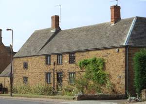
Still going south, on our left we come to a narrow opening called the Tchure. Standing here you can see that the opposite side of the street is lined with substantial old houses, mostly former farm houses which have been converted into residences, a hotel or a garage. A notable example is the 17th-century Maund's Farmhouse which, at that time, was owned by Christ Church, Oxford. It incorporates part of a 12th century manor house, was rebuilt in the early 17th century and altered again in the 18/19th centuries. Just past the Tchure on the left is the former Royal British Legion Club which used to be an axletree factory (an axletree is a crossbar that fitted to the underside of wagons and coaches). The owners, the Mason family, established the factory in about 1820 and in 1851 it was known to employ 24 men and 4 boys. It exported to many countries and is thought to have supplied axles for the royal coaches. It closed around 1895 when the patent was sold.


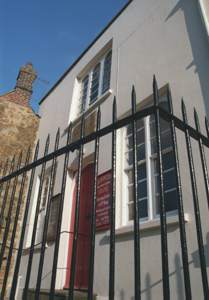
We will come back to the main street shortly but we now turn back and into the Tchure - which leads back to the Market Place. Tchure is an old name commonly used in the Midlands for a narrow lane. It certainly has a narrow exit into the Market Place! Going south we come to the Unicorn Inn, a 17th century building which was once the Unicorn Commercial Inn; it was given its present front in the 19th century. The 'Queen' stagecoach left here each morning for Oxford, calling again each evening on its way to Banbury. As we turn the corner into Hudson Street opposite us is Pretoria House. Deddington celebrated the relief of Mafeking by burning President Kruger in effigy on a big bonfire. A wind got up and sparks carried to the thatched roof of the farmhouse on Pretoria's site which was burnt down. It was reconstucted of the old materials in 1905. Halfway along Hudson Street on the north side is a small building erected by a Victorian, Charles Duffel Faulkner (Fellow of the Society of Antiquaries) as a private museum. The contents of the museum have been dispersed but a number of geological specimens remain built into an adjoining wall which is now part of a cycle shop (Cyclogical - they will happily let you have a look!). Faulkner also rebuilt the house almost opposite, now called Priory Dene, which is notable for its unusual Gothic metal windows with coloured glass.
We are now back on the main street and going south from here it is called New Street. It looks like an extension of High Street but it has been known as New Street since the early 13th century! In fact, High Street was also New Street until relatively recently. On the opposite side of the road are the buildings of another former 17th century farm - Grove Farm. Now it is a group of private houses of which the main one - Grove House - retains its unusual mullioned windows and latticed lights.


On our left going down New Street we pass the Crown and Tuns pub, an old coaching inn, and opposite is Park Farm, another 17th century house which from the 19th century served a large farm. Still on the left we pass a number of imposing houses including Ilbury House (a stone house that, unusually for Deddington, was stuccoed - a facing which became fashionable in the 18th century) and The Old Post House (which has been much altered). We shortly come to two of the most notable houses in the village and they face one another: Leadenporch House and Deddington Manor. Leadenporch House, from which a large estate took its name and from which it is now remote, is an ancient farmhouse. It is significant as one of the earliest and most complete mediaeval hall houses in the area; it dates from c. 1325. There is no trace of a porch but it does have an early 14th century pointed arched doorway. It has been much changed and in 1834 was known to be a beer shop "in a state of dilapidation"; shortly afterwards it was repaired and some of the surviving Gothic detail is probably of this period.
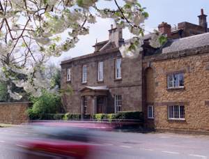
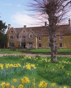
In the architectural context of the village, Deddington Manor looks very unusual. It was built in neo-classic style (probably around an older core) in about 1800 as a small country house - notice the fine dressed stone facing (called ashlar). Extensions were built around 1840 and the Doric porch is a later addition. At the rear of the house is a landscaped park of about 30 acres.
Still on the left of New Street we pass a narrow lane called the Stile and come to Quinque House which Mary Vane Turner described as 'a monotonous row of cottages'. Dating from the early 18th century, these cottages were converted from premises used as a workhouse. When the Poor Law Unions were established by the Act of 1834, the building was sold into private hands and recently became a single house. It was described in a legal conveyance of 1840 as 'all that freehold messuage or tenement, yard, garden buildings and premises to the same belonging situate and being in the New Street in Deddington aforesaid and hereto fore used as a workhouse for the said parish'. Shortly after, we reach Plough House, formerly the Plough Inn, a much altered 17th century house above a 15th century vaulted cellar; it was an inn by 1774 but may have been a merchant's house in the Middle Ages.


We now backtrack and go along the Stile (notice the traditional guttering on the barn to your left) to Goose Green. The green is overlooked on the south by the Mount, a modernised 17th century house, once the Bishop's Arms Inn, and on the west by a row of 18th century cottages, of which one bears the date 1757. The stone building at the bottom of the green (now Baerlein House) was built in 1849 as a coal house for the Deddington coal charity (see below) and was later used to house the parish fire engine - which was previously kept in the church!
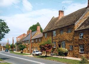
We now travel up Philcote Street which, like other streets in this part of the parish, is lined with ironstone cottages, and reach Chapel Square. In the square (formerly Tabernacle Square) is the mid-19th century Wesleyan Reform chapel. It is a stuccoed building with Tudor-styled windows. There is a long history of non-conformist religion in Deddington. A report of 35 dissenters in the town in 1676 is thought to be an underestimate and with the development of Methodism this number was greatly increased; by 1827 there were said to be about 400 dissenters - about a quarter of the population.
Just past the chapel we will shortly turn north up Church Street but before doing so we look east along Castle Street towards a large house called Castle End and also, to the south, the remains of Deddington Castle. Castle End was called Blount's Farm in the 19th century and in earlier times, stood almost alone at the east end of the village. It has a long front portion in two parts with a central gabled porch dated 1647. The southern part, rebuilt in the late 18th century, incorporates a late mediaeval hall and the original (c. 1500) doorway. The other part is consistent with the date on the porch and includes a large hall and tall ovolo-mullioned windows.
Today, all that can be seen of the castle is a large grassy mound topped with trees. It is known to have existed before 1100, its construction probably ordered by Odo of Bayeux (half brother of William the Conqueror) soon after the conquest. Its custody was still a matter of royal concern in the reign of King John but in 1277 it was described as "an old demolished castle" and by 1377 the canons of Bicester were buying dressed stone from the castle walls. It had a substantial motte and bailey structure. Excavations in 1947 and 1977 showed that the inner bailey was surrounded by a wall 7ft 6in thick and that there was a rectangular tower of fine dressed stone. Against the curtain wall was a hall (c. 1160) and a solar wing; there was also a large chapel with nave and chancel (probably 13th century). The natural ampitheatre of the bailey encouraged its use for recreational activities and in the mid 19th century a large thatched building called the Pavilion was built to provide a ballroom and a refreshment room for a club supported by the gentry rather than the villagers. At this time the lodge at the castle gates was occupied by a professional who supervised a Gentleman's Cricket Club and an Archery tournament. The Pavilion was removed before the Second World War and the site was sold by the Ecclesiastical Commission to the parish council. The site is a scheduled ancient monument (National Monument No. 21807) occupying 8.5 acres and is still used for recreational purposes.

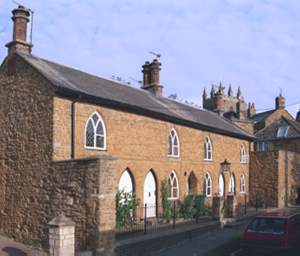
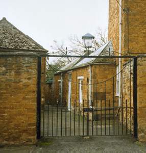
Now moving north along Church Street we come to the almshouses on our left. They were completed in 1822 and comprise a two-storeyed terrace of 4 tenements with octagonal brick chimneys and pointed windows with Gothic tracery. From time immemorial rents from various lands and tenements had been used to help the poor of Deddington. In 1612 the Commissioners of Charitable Uses nominated 12 feoffees (holders of a piece of land) to administer Deddington's charities. Over the years they acquired more land and property. In 1818 newly appointed feoffees bought land in Church Street and built the almshouses. In 1856, after much agitation about misappropriation of funds, the Attorney General directed that half the surplus income from the newly called Deddington Charity Estates should support a coal charity (see above), and half the surplus for the National Schools. In 1871 £44 was spent on each. The coal charity ceased in 1910. The feoffees still operate today although they are now called trustees. Their main tasks are responsibility for the maintenance of the town hall and the almshouses.


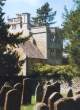
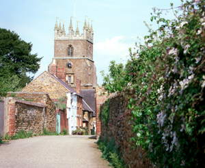
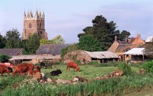
Turning the corner, we have the Parish Church of St Peter and St Paul on the northside, and opposite, on the southside, the late 17th century Old Vicarage now a private house which was rebuilt in 1822. The church stands on high ground and, even without its original spire, its tall (31m), buttressed, squat-based 17th century tower is a dominant feature of the local landscape. There was a church on this site in Norman times and it first appears in historical records in 1254. There is evidence of major building in the 13th century and significant changes in later centuries. The church contains the notable Jones Memorial windows.
In 1634 its tall spire, 'the most noted of all Oxfordshire and seen the furthest' fell and carried the bells with it. During the Edgehill campaign of the Civil War (about 15m from Deddington), the royal army was very short of ammunition and the church bells, lying idle since the tower had collapsed, did not escape the King's spies. On 21 January 1643 Charles I ordered their removal with the promise that they would be replaced. The pledge was not honoured. Another set of 6 bells was cast in 1791 and the treble and second replaced in 1946.
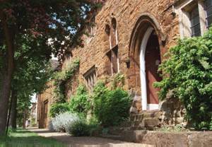
Approaching the Market Place and turning north, we pass the rear entrance to the church and reach the gateway to Castle House on our right with the Bullring on our left. Castle House, hitherto the Old Parsonage and the Great House, is so-called because of its long association with the Castle estate of which it was at times effectively the manor house. It is based on a tower-like structure of 13th century origin containing a small chapel. The medieval structure was largely rebuilt in the 17th century by the wealthy Thomas Appletree whose initials are on the rainwater heads with the date 1654. In 1894 the then owner, H.R. Franklin, carried out a lot of restoration work, including the south-facing porch and bay window. The east front was reconstructed in 1925 after a fire.
In 1312, after his surrender to the earl of Pembroke, Piers Gaveston, who was a favourite of Edward II, was lodged in Castle House. It was here on June 12 he was seized by Guy, Earl of Warwick, and carried off to be executed at Blacklow Hill in Warwickshire. In 1643 Charles I was given shelter in the house after the battle of Cropredy Bridge. In 1649 the town was again briefly involved in national affairs when many Levellers were quartered here. The Levellers were a republican party in the parliamentary army and were crushed by Cromwell in that year.


Opposite Castle House gateway and east of the church the two long blocks of buildings may originally have been the sites of market stalls and shops . The north-south row is 17th century and the east-west row, which divides the Bullring, was known to exist in 1808. A brick warehouse was added to the latter during the 19th century and is now residential apartments.
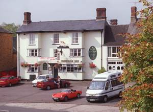
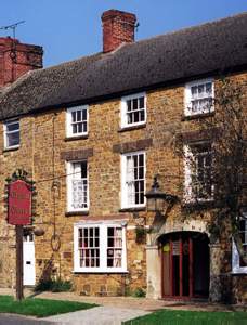
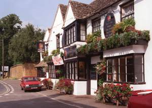
Looking to the north side of the Market Place we see a row of substantial houses of widely differing appearance built between the mid 17th and late 18th centuries. One of the most interesting, and oldest, is the Three Horseshoes which was originally an inn of that name. It was entirely rebuilt in 1948-9 from a near ruin and is notable for its elaborate 16th century type doorway with deeply moulded jambs and a four-centred arch. A little further on is the Deddington Arms (formerly the King's Arms) hostelry. Although much altered it dates from the early-mid 16th century and is a rare example of a partially timber-framed building in this area. It retains a 17th century gabled front with stone mullioned windows and 16th century chimney stacks. The stagecoaches 'Rival' and 'Regulator' called here daily on their way to Oxford and on their return to Banbury or Warwick.
We now turn to look south across the Market Place and to the Town Hall from where we started our walk. We hope you have enjoyed it.
An alternative walk and information is available in Discovering Deddington, a millennium guide book published by the Deddington Map Group.