Millennium Project
This is a rather more ambitious walk of about 5½ miles, possibly even a little more, but it really does take you around the Parish.
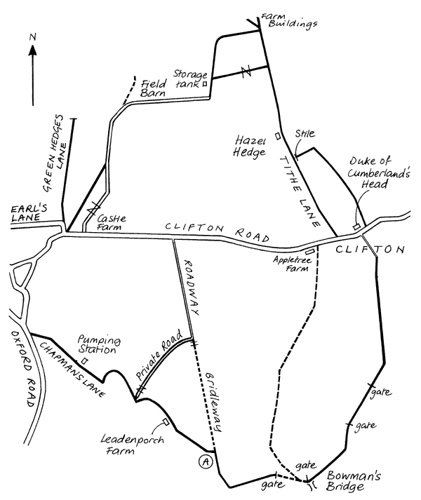
The first part, starting down Chapman's Lane, I described in Walk 1. Where I have marked "A" on this map turn right instead of left on the bridleway along a broad grassy stretch between hedges. At the end turn sharp left and keep along the edge of the field. At the corner is a gate and a blue arrow to direct you straight across a large field past a tree on the left to a wooden gate visible in the distance. Remember to close it after you as there are often sheep in the field, and ensure your dog is under control. You strike across to the right along a narrow track curving round the side of the hill, down to a wooden gate on the left. The approach can be very muddy in wet weather. Nearby on the right a stream winds down to Bowman's Bridge a small stone structure. The gate leads into a field along which is a fairly rough path beside a tall hedge and the occasional tree. At the end of the field another wooden gate bears a Bridleway sign. There is now a broad grassy path along the hedge which takes you round to a large gate. Through this you will find quite a wide, though rutted, pathway beside a field with a barbed wire fence on your right. At the end you pass through a gate into the long, grassy, in places rather muddy lane up to Clifton. The Thames Water Works are on your left and the anglers on your right just before you enter the village.
The distance so far is about 3 miles; allow a good 55 minutes. You can return on the Clifton Road, but I find it much more interesting to cross over to Tithe Lane and venture out into the country. (There is an alternative footpath further down the road towards Aynho which leads to a stile about a quarter-mile up Tithe Lane just past Hazel Hedge. It is not easy to find your way here, though). It is quite a long walk up Tithe Lane. After about quarter-of-an-hour a broad gravel up-hill path going off to the left is not a right-of-way. You should go on till you see some derelict farm buildings ahead and then turn into the field on your left and climb steeply keeping close to the hedge on your right.
At the top on the corner is a gap with a splendid view: the Stilgoe farm with its dominant blue Silo towers and both Adderbury and King's Sutton churches can be seen from here. Bear left and follow the pathway to the top of the gravel up-hill path where on the corner looms a large black storage tank. Turn left here and soon right, along a wide track down to the farm buildings at Field Barn. On this section you can be exposed to some penetrating Westerlies You will then come on to the very clean concrete roadway that comes out on the Clifton Road beside Castle Farm. However, the last section is not a right-of-way and you should bear right through the last two fields, crossing the wooden bridge between them. You arrive at the stile on the corner near Earl's Lane. Allow 55 minutes from Clifton.